Chapter 3
MERIS Instrument
3.1 Instrument Description
A detailed description of the MERIS instrument is
provided in document R-11.
also available
online.
3.1.1 The MERIS instrument
MERIS is a programmable, medium-spectral resolution,
imaging spectrometer operating in the solar reflective
spectral range. Fifteen (15) spectral bands can be
selected by ground command, each of which has a
programmable width and a programmable location in the
390 nm to 1040 nm spectral range.
The instrument scans the Earth's surface by the so
called 'push broom' method. CCDs arrays provide spatial
sampling in the across track direction, while the
satellite's motion provides scanning in the along-track
direction.
MERIS is designed so that it can acquire data over
the Earth whenever illumination conditions are suitable.
The instrument's 68.5° field of view around nadir covers
a swath width of 1150 km. This wide field of view is
shared between five identical optical modules arranged
in a fan shape configuration (see Figure
3.3 - ). In the calibration mode, correction
parameters such as offset and gain are generated, which
are then used to correct the recorded spectra. This
correction can be carried out either on board or on the
ground.
The Earth is imaged with a spatial resolution of 300
m (at nadir). This resolution is reduced to 1200 m by
the on board combination of four adjacent samples across
track over four successive lines.
The scene is imaged simultaneously across the entire
spectral range, through a dispersing system, onto the
CCD array. Signals read out from the CCD pass through
several processing steps in order to achieve the
required image quality. These CCD processing tasks
include dumping of spectral information from unwanted
bands, and spectral integration to obtain the required
bandwidth. On-board analogue electronics perform
pre-amplification of the signal and correlated double
sampling and gain adjustment before digitisation. The
on-board digital electronics has three major functions:
it completes the spectral integration, performs offset
and gain corrections in full processed mode, and creates
the reduced-resolution data when required.
The calibration of MERIS is performed at the orbital
South pole, where the calibration diffuser is
illuminated by the Sun by rotating a calibration
mechanism.
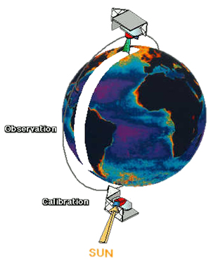
Figure 3.1 - Observation / calibration
cycle.
The engineering requirements on the instrument, which
have been derived from the Envisat mission requirements,
are as follows:
- Spectral range: 390 nm to 1040 nm
· Spectral resolution: 1.8 nm
· Band transmission capability: Up to 15 spectral
bands, programmable in position and width
· Band-to-band registration: Less than 0.1 pixel
· Band-centre knowledge accuracy: Less than 1 nm
· Polarisation sensitivity: Less than 0.3%
· Radiometric accuracy: Less than 2% of detected
signal, relative to sun
· Band-to-band accuracy: Less than 0.1%
· Dynamic range: Up to albedo 1.0
· Field of view: 68.5o
· Spatial resolution: 300 m at nadir |